


Valggodemard rif du sap a la lavine

ejacky
User
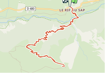

Length
7.9 km

Max alt
1973 m

Uphill gradient
743 m
Km-Effort
17.8 km

Min alt
1309 m

Downhill gradient
744 m
Boucle
Yes
Creation date :
2025-06-14 15:33:33.041
Updated on :
2025-06-14 15:34:49.15
4h03
Difficulty : Difficult

FREE GPS app for hiking
 SityTrail
IGN / Geographical institutes
SityTrail Plus
The world is yours!
About
Trail Walking of 7.9 km to be discovered at Provence-Alpes-Côte d'Azur, Hautes-Alpes, La Chapelle-en-Valgaudémar. This trail is proposed by ejacky.
Description
rif du sap a la lavine
Positioning
Country:
France
Region :
Provence-Alpes-Côte d'Azur
Department/Province :
Hautes-Alpes
Municipality :
La Chapelle-en-Valgaudémar
Location:
Unknown
Start:(Dec)
Start:(UTM)
283406 ; 4967418 (32T) N.
Comments